- What does a geography map of ancient Greece show?
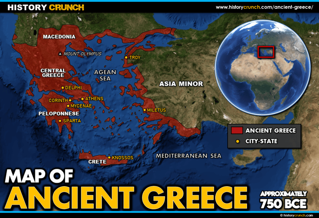
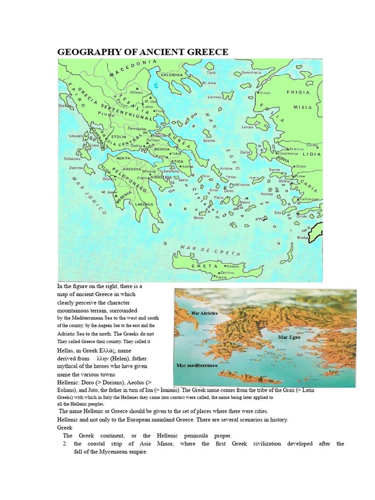
- A geography map of ancient Greece displays mountain ranges like the Pindus, major seas such as the Aegean and Ionian, significant rivers, and the strategic locations of prominent city-states like Athens, Sparta, and Corinth, highlighting their natural defenses and access to trade.
- How did the geography of ancient Greece influence its development?
- The mountainous terrain fragmented ancient Greece into independent city-states, fostering unique political systems and frequent inter-city conflicts. Its extensive coastline and numerous islands promoted maritime trade and colonization, connecting Greece to the wider Mediterranean world.
- Where can I find an HD geography map of ancient Greece?
- You can find high-definition geography maps of ancient Greece on educational websites like the University of Texas at Austin's Perry-Castañeda Library Map Collection or specialized historical atlases. Many digital humanities projects also offer interactive HD maps.
- What were the main geographical regions of ancient Greece?
- The main geographical regions included mainland Greece (e.g., Attica, Boeotia, Peloponnese), the numerous Aegean Islands (e.g., Crete, Rhodes), and Greek colonies across Asia Minor and Magna Graecia, each with distinct geographical characteristics.
- Why was the Aegean Sea so important in ancient Greek geography?
- The Aegean Sea was critical as a highway for trade, cultural exchange, and military expeditions. Its countless islands served as stepping stones for colonization and naval bases, directly shaping Greek expansion and interaction with neighboring civilizations.
- How did mountains impact ancient Greek city-states?
- Mountains created natural barriers, isolating city-states and contributing to their fierce independence and diverse political structures. They also provided defensive advantages but made land travel and communication challenging, fostering strong regional identities.
- What major rivers are significant on an ancient Greece map?
- While ancient Greece lacked massive rivers like Egypt or Mesopotamia, rivers like the Eurotas (Sparta), Cephissus (Athens), and Alpheios (Olympia) were vital for local agriculture and religious practices, though none were navigable for long distances.
Uncover the foundational geography of ancient Greece with our comprehensive guide designed for explorers aged 20-45. Delve into the intricate relationship between its mountainous terrain, numerous islands, and sprawling coastlines, and how these features shaped its powerful city-states and rich history. Explore the strategic importance of the Aegean Sea, the rugged Peloponnese, and the fertile plains that fostered early civilizations. This informational resource offers essential insights into historical maps, political boundaries, and key geographical landmarks that defined this influential civilization. Discover how ancient Greek geography impacted trade routes, military strategies, and cultural development, making it an indispensable tool for students, history buffs, and travelers planning future adventures.
- What key features are visible on a geography map of ancient Greece? - A typical geography map of ancient Greece clearly displays its rugged mountain ranges like the Pindus, vital waterways such as the Aegean and Ionian Seas, and prominent river systems. It also pinpoints the locations of influential city-states, revealing how natural barriers and coastal access defined their territories and interactions.
- How did the ancient Greek topography influence its city-states and culture? - Ancient Greek topography, characterized by mountainous terrain and numerous islands, naturally led to the development of independent city-states. This geographical fragmentation fostered unique political systems, distinct cultural identities, and frequent inter-city conflicts, while also promoting seafaring and trade across the Mediterranean.
- Where can I access detailed, interactive maps of ancient Greece's geography? - For detailed, interactive maps of ancient Greece's geography, explore reputable online resources such as the Perseus Digital Library or the World History Encyclopedia. These platforms often provide high-resolution, zoomable maps with layers showing topographical features, historical settlements, and trade routes, perfect for in-depth study.
- What role did the Aegean Sea play in the geography and history of ancient Greece? - The Aegean Sea was paramount to ancient Greek geography and history, serving as a crucial highway for trade, colonization, and cultural diffusion. Its numerous islands facilitated navigation and acted as strategic outposts, directly influencing Greek expansion and interactions with other civilizations across the Mediterranean basin.
- Which major landforms defined the Peloponnese region on an ancient Greek map? - The Peloponnese region, a large peninsula in southern Greece, was defined by significant mountain ranges like the Taygetus and Parnon, fertile river valleys such as the Eurotas, and extensive coastlines. These landforms isolated its various city-states, most notably Sparta, shaping their distinct militaristic societies.
- How did geographical isolation impact the political structure of ancient Greek cities? - Geographical isolation, primarily caused by mountainous terrain, severely limited overland communication and travel between ancient Greek cities. This fostered a strong sense of independence and self-sufficiency, leading to the development of diverse political structures like democracies, oligarchies, and monarchies, rather than a unified empire.
- What are the best map images to understand ancient Greek trade routes? - To understand ancient Greek trade routes, seek out specialized historical maps that highlight maritime passages and port cities. Look for **Maps** depicting the Mediterranean and Black Seas, showing routes connecting mainland Greece, the Aegean islands, Asia Minor, and Magna Graecia, essential for tracing economic networks.
Ready to unlock the secrets of ancient Greece? Understanding its geography is key to grasping its epic history. For Gen Z and Millennials, visualizing ancient landscapes transforms textbook facts into tangible adventures. Forget dusty old maps; we're diving into the geographical foundations that shaped everything from democracy to legendary battles. Let's explore how the land itself created the powerful civilization we still talk about today.
Frequently Asked Questions
Where can you find the best geography maps of ancient Greece?
For high-quality, detailed geography map of ancient greece resources, digital archives and educational platforms are your go-to. Try institutions like the Perseus Digital Library from Tufts University and the extensive map collections at the World History Encyclopedia. They offer excellent historical and physical maps.
How can Maps help you explore ancient Greek geography?
Pull up your preferred mobile Maps app to visualize modern overlays of ancient sites. Check historical map layers for regions like Athens or Sparta to understand their regional context. Use these Local MAP tools to trace historical routes and grasp the distances between prominent city-states.
What are the best times to study ancient Greek geography maps?
The best time to delve into ancient Greek geography maps is during dedicated study sessions or while consuming historical content. Use interactive maps to explore Aegean Sea trade routes or the rugged Peloponnese regions while watching documentaries or reading historical accounts for enhanced context.
Quick Guide to Ancient Greek Geographical Features
- Aegean Sea: Eastern boundary, crucial for trade and naval power.
- Ionian Sea: Western boundary, connecting Greece to Italy.
- Peloponnese Peninsula: Southern mainland, home to Sparta and Olympia.
- Attica Peninsula: Northeastern mainland, home to Athens.
- Pindus Mountains: Spine of mainland Greece, creating isolated valleys.
- Isthmus of Corinth: Narrow land bridge connecting Peloponnese to mainland.
All maps focus on geography map of ancient greece.
Comprehensive overview of ancient Greek physical geography, exploration of major city-states in geographical context, analysis of how terrain influenced historical development, insights into key waterways like the Aegean and Ionian Seas, identification of significant mountain ranges and valleys, understanding the distribution of resources and trade routes, detailed maps highlighting historical boundaries, focus on the Peloponnese and mainland Greece regions, and the influence of insular geography on Greek culture.

:max_bytes(150000):strip_icc()/A_history_of_the_ancient_world_for_high_schools_and_academies_1904_14777137942-627373d79afa4e95b8ee626a506a1916.jpg)


Geography In Ancient Greece At Thelma Guerrero Blog Map Of Ancient Greece . Geography In Ancient Greek Times At Caren Knuckles Blog A History Of The Ancient World For High Schools And Academies 1904 14777137942 . 04 Ancient Greece Geography Ancient Ancient Greece Map Geography And Geology 3000 BCE To 2025 CE V763 1200x560 . Explore The Ancient Greek World Through A Digital Map Map Ancient Greece Public Domain 768x442 . Explore Labeled Ancient Greece Maps A Journey Through Time Ancient Greece Map Labeled Edited 1024x536


Ancient Greece A Land Shaped By Geography Ancient Greece Map 1024x699 . 03 History Of Ancient Greece Periods Overview Ancient Greece Map Illustrated Highlights 3MA To 30 BCE V740 . 04 Ancient Greece Geography Ancient Ancient Greece Map Geography Pre3000 BCE To 200 CE V754 1536x717 . Ancient Greek Philosophy Art Democracy Britannica Ancient Greece . Geography Of Ancient Greece The First Geography Of Ancient Greece


Geography Of The Ancient Greek World And Aegean Map Artofit . Geography Of Ancient Greece Ducksters At Hubert Moreno Blog Ancient Greece Map 1024x817 . Ancient Greece Geography Map Ancient Greece Geography And Antique Maps . Geography Of Ancient Greece Ducksters At Hubert Moreno Blog Map Greece Topological Lg . Maps Of Ancient Greece 6th Grade Social Studies 1077403 Orig


Navigating The Cradle Of A Map Of Ancient Greek Cities . Geography In Ancient Greece At Thelma Guerrero Blog . Ancient Greece Maps Legend And Design Notes Ancient Greece Screenshot 2025 05 25 At 8.13.52 AM . Geography In Ancient Greece At Thelma Guerrero Blog Pasted Image 0 9 . Geography Of Ancient Greece Overview PDF Greece Greeks 1


Detailed Map Of Ancient Greek Regions Stable Diffusion Online All D2572a41 Dfcd 42be 8c77 . Map Of Ancient Greece Circa 700 BCE Map Ancient Greece Circa 700bce Large . Ancient Greece World Geography Map Printable Activity 750f 15152098 1 . Unit 5 Ancient Greece Map Activities By Room 40 Resources TPT 750f 13796914 3 . Ancient Greek Map Of The World Free Printable Map Map Of The Greek City States C 500 Bce World History Scaled


Ancient Greece Maps Resources Map Ancient Greece Circa 700bce Small . Geography Of Ancient Greece F174705 666 0b42 Dd62 Ancient Athens Greece . Explore Ancient Greece A Detailed Labeled Map For History Buffs Hq720 . Maps Geography In Ancient Greek Tales Ancient Mythology 1771446106 . Geography Of Ancient Greece Map Cities Climate Greek Mythology Greece.webp


File Physical Map Of Ancient Greece Grc Svg Wikimedia Commons 250px Physical Map Of Ancient Greece Grc.svg . Ancient Greece Map Mountains Il E4os . Map Of Ancient Greece City States Dara MAP Ancient Greece Map With City States And Iconic 1 . Ancient Greece A Land Shaped By Geography Infographic Of The Site Where The Greek Polis Developed Cities Of Ancient Greece And Location Of The Most Important Ones Quarkxpress Qxp Adobe Indesign Indd 4960x3188 2NEBR8W . Ancient Greece Geography Map